Accident hotspots in Medway (Gillingham): where crashes cluster
Police recorded 430 road collisions in Medway (Gillingham) in 2025. We mapped every one to find the junctions and roads where they concentrate.
67.3
Road Risk Score
Medway (Gillingham) ranks 19 of 125 towns we score — band D, above average
101.8 people killed or seriously injured per 100,000 residents, 260.9 vehicle crimes per 100,000, 50.5% of collisions involving someone outside a car, and a five-year trend of -10%. How the score works.
Vulnerable road users in Medway (Gillingham) (2025)
115 of Medway (Gillingham)'s 430 collisions (27%) involved pedestrians; 39 of Medway (Gillingham)'s 430 collisions (9%) involved cyclists; 63 of Medway (Gillingham)'s 430 collisions (15%) involved motorcyclists. Together those collisions left 79 people killed or seriously injured.
| Road user | Collisions | Share of all collisions | Killed or seriously injured | Serious-outcome rate |
|---|---|---|---|---|
| Pedestrians | 115 | 27% | 42 | 37% |
| Cyclists | 39 | 9% | 11 | 28% |
| Motorcyclists | 63 | 15% | 26 | 41% |
69 of Medway (Gillingham)’s collisions in 2025 involved a child casualty.
Medway (Gillingham)’s busiest collision clusters (2025)
Each circle is a ~100m cluster of police-reported collisions. Larger circles = more collisions; red = at least one death. Click a circle for details.
The short answer
Medway (Gillingham) recorded 430 police-reported collisions in 2025 — broadly flat year-on-year, or about 391 per 100,000 residents. Its most stubborn risk is Luton, a hotspot in 4 of the last 5 years.
430
Collisions in Medway (Gillingham) (2025)
532
People injured or killed
+1.7%
Change vs 2024
~413
Modelled collisions in 2026 on current trend
Medway (Gillingham)’s junctions that stay dangerous
These locations recorded multiple collisions in at least four of the last five years (2021–2025) — a persistent pattern, not a one-off bad year.
Luton
A2
15 collisions across 4 hotspot years · 21 casualties · 1 serious or fatal
The Brook, Luton
A231
12 collisions across 4 hotspot years · 18 casualties · 2 serious or fatal
Maidstone Road, Snodhurst
A230
11 collisions across 4 hotspot years · 22 casualties · 3 serious or fatal
Medway (Gillingham)’s worst accident spots
| # | Location | Road | Collisions | Casualties | Serious | Fatal |
|---|---|---|---|---|---|---|
| 1 | Pier Road, St. Marys Island | A289 | 5 | 7 | 0 | 0 |
| 2 | Four Elms Roundabout, Frindsbury Extra | A289 | 4 | 5 | 1 | 0 |
| 3 | Cuxton Road, Strood | A228 | 4 | 5 | 1 | 0 |
| 4 | High Street, Strood | A2 | 3 | 4 | 0 | 0 |
| 5 | The Brook, Luton | A231 | 3 | 4 | 0 | 0 |
What to do with this: if your regular routes cross the junctions above, they deserve extra care at peak times — these aren’t random locations, they’re where collisions repeat. For context, Medway (Gillingham)’s rate of 391 per 100,000 residents compares with an average of 220 across the 125 areas we track. A junction with a documented five-year history is also the strongest evidence a campaign can put in front of a councillor.
Vulnerable road users in Medway (Gillingham) in 2025: 115 collisions involved a pedestrian, 39 a cyclist and 63 a motorcyclist — overall, 390.9 collisions per 100,000 residents.
Area definition: figures cover 6km radius of the town centre. Per-100k rates use the mid-2023 ONS population estimate for the named town or district; where the area is radius-defined, treat the rate as indicative.
These figures come from the Department for Transport’s STATS19 dataset — every collision reported to the police in 2025 — clustered to roughly 100 metres and labelled via OpenStreetMap. Only police-reported incidents are included, so minor damage-only bumps are undercounted. See the full UK hotspots analysis for the national picture and methodology.
Need this cut a different way? A junction’s full history, cyclist or pedestrian casualties on their own, or a before-and-after on a scheme: we produce those, free for community groups, campaigners and journalists.
Medway (Gillingham) over 5 years
Collisions per year in Medway (Gillingham)
2025: 430 (up 1.7% on the year before) · peak 499 in 2022 · -10% across the period
Axis clipped to the data range to show year-on-year movement.
2022 was Medway (Gillingham)’s worst year of the period with 499 collisions, against 423 in 2024. Of 2025’s 532 casualties, 112 were killed or seriously injured (3 deaths, 109 serious).
Build the Medway (Gillingham) story from this page
Every line below is computed from the official DfT STATS19 dataset and updates when new data is released — copy, check, publish. Free to use with a link to this page as the source.
- “Police recorded 430 road collisions in Medway (Gillingham) in 2025, injuring or killing 532 people (DfT STATS19).
- “2022 was Medway (Gillingham)'s worst year of the last 5 (499 collisions, against 423 in 2024).
- “Medway (Gillingham)'s collision rate is 391 per 100,000 residents, against an average of 220 across the 125 areas we track.
- “115 collisions involved pedestrians, 39 collisions involved cyclists, 63 collisions involved motorcyclists — with 79 of those people killed or seriously injured.
- “69 collisions in Medway (Gillingham) involved a child casualty in 2025.
Attribution: “Analysis by Swift Assist (swiftassistuk.co.uk) of DfT STATS19 data” with a link to this page. Methodology: how we process the data.
How Medway compares nationally
Medway is the highway authority for these roads, which means the same body counted in the national comparison below is the one that maintains them.
Per mile driven
65 of 192
Per resident
72 of 188
Risk band
Above average
Five-year trend
down 9.8%
The full record for Medway — severity-adjusted casualties, the breakdown of who is being hurt, the darkness and ice profile, and a comparison against its ONS statistical neighbours rather than the national average — is on its own page.
Medway’s full road risk record →What actually changes the odds in Medway (Gillingham)
Data is only useful if it changes what you do. These three are picked from Medway (Gillingham)’s own figures above, each with the number that prompted it. Every guide explains how the thing works before it suggests buying anything, and most cost less than a third of a typical insurance excess.
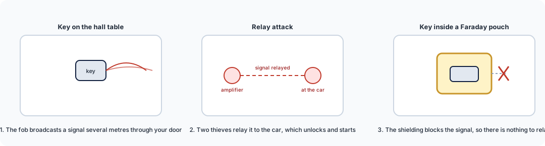
Faraday key pouch / box
£9–£25
Medway (Gillingham) records 261 vehicle crimes per 100,000 residents, above the median of the towns we track. Keyless relay theft is the leading route into modern cars, and a signal-blocking pouch ends that method outright for under a tenner.
How it works →
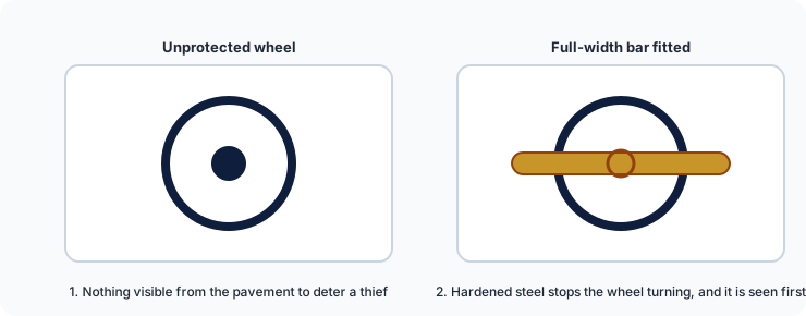
Steering wheel lock
£40–£70
Vehicle theft is target selection: thieves work a street and take the easiest car. A visible attack-rated bar moves your car down that list before anyone touches it.
How it works →
Alarmed disc lock
£20–£50
Motorcyclists are in 15% of Medway (Gillingham)'s collisions, and bikes are also lifted rather than ridden away. An alarmed disc lock covers the theft half for about £30.
How it works →
We are a data business, not a retailer: these link to our guides, which link on to retailers. Some of those links earn us a small commission at no cost to you, and we hold no stock and take no payment for placement. All security guides.
Related on Swift Assist
UK accident hotspots (national)
Britain's 20 worst collision clusters, mapped from official data.
Read more →Cyclist collision map (national)
Where cyclists are hurt across Britain, from the same records.
Read more →Free data for campaigners
Junction histories, corridor studies and custom cuts, free for community groups.
Read more →Need this data for your own work?
Site and junction reports from £95, next working day. Free for community groups, campaigners and journalists.